
Lake Effect Snow Warning
A Lake Effect Snow Warning means heavy, localized snowfall from lake-effect snow bands is expected to create hazardous conditions in the affected area. It is issued by the National Weather Service (NWS) and most commonly affects areas downwind of the Great Lakes, although lake-effect snow can also occur near other large bodies of water.
Lake-effect snow behaves differently from typical winter storms because it develops in narrow, intense bands. One neighborhood can receive a foot of snow while a town just a few miles away gets very little. This localized and rapidly changing nature is why checking conditions for your exact location is important.
What Causes Lake Effect Snow
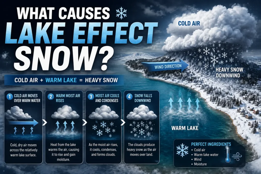
Lake-effect snow forms when cold air moves across a large body of relatively warmer water, picking up moisture and heat before dumping it as snow on the downwind shore.
Cold Air, Warm Lake Water, and Moisture Pickup
The process starts with a temperature difference. In late fall and winter, air masses moving down from Canada are often far colder than the water in the Great Lakes, which takes months to cool down and can stay unfrozen well into winter.
As that cold air travels over the warmer lake surface, it picks up moisture and heat from the water below. This makes the air unstable warmer and lighter at the bottom, colder above so it starts to rise. Meteorologists often refer to this temperature difference as “delta-T”: the bigger the gap between the lake surface and the air a few thousand feet up, the stronger the instability and the heavier the potential snowfall.
As the moist air rises, it cools, condenses, and forms clouds. By the time that air reaches the opposite shore, it can release intense, highly localized snow.
Wind Direction, Fetch, and Why Snow Bands Are So Narrow
Wind direction determines exactly where the snow falls. Lake-effect snow bands typically form parallel to the wind and align with the lake’s longest open-water stretch in that direction a distance meteorologists call “fetch.” A longer fetch gives the air more time over the water, allowing it to pick up more moisture before reaching land.
This is why lake effect bands are so narrow and why totals can vary so sharply over short distances:
- A shift in wind direction of just 10–20 degrees can move a snow band from one county to the next.
- Areas directly downwind of the longest fetch often see the heaviest, most persistent bands.
- Areas just outside the band may get little more than flurries.
The result is a storm that can feel wildly different from one town to the next, even when both are only a short drive apart.
Lake Effect Snow Warning Criteria (And Why They’re Not the Same Everywhere)
There is no single, nationwide snowfall threshold that triggers this warning. Local NWS forecast offices set their own criteria based on how the surrounding region typically responds to snow, so amounts that trigger a warning near Lake Ontario may differ from those near Lake Erie or the Great Salt Lake.
In general, offices consider:
- Expected snowfall rate — how fast snow is accumulating, not just the total.
- Total expected accumulation over a set time window, often 12 or 24 hours.
- Visibility — whether snow is falling heavily enough to create whiteout conditions.
- Duration — how long the lake-effect band is expected to persist over the same area.
Snowfall rate can matter as much as total accumulation. A narrow band producing 2–3 inches per hour can shut down roads faster than a broader storm that drops more total snow over a full day, because plows and drivers simply can’t keep pace.
Not Every State Calls It the Same Thing
Whether you see a standalone warning by that name or the same hazard folded into a “Winter Storm Warning” depends on which NWS forecast office covers your area not on a single national rule.
Where NWS Issues a Lake Effect Snow Warning vs. Where It’s Folded Into a Winter Storm Warning
This standalone product has had an inconsistent history. It was discontinued nationwide in 2018, when NWS temporarily folded lake-effect snow hazards into the standard Winter Storm Warning everywhere. The product was reinstated for the 2019–20 winter season but reinstatement was left optional at the regional level, so practice still isn’t identical across the country.
As a general pattern:
- Eastern Region offices — including those serving parts of New York, Pennsylvania, and Ohio are more likely to issue a standalone warning for lake-effect events near Lakes Erie and Ontario.
- Central Region offices — serving areas such as Michigan, Wisconsin, Indiana, Illinois, and Minnesota more commonly incorporate lake-effect snow into the Winter Storm Warning product instead of issuing it separately.
This isn’t a strict “some states do, some states don’t” split. It comes down to which forecast office is responsible for your county, and that office’s judgment about which product best communicates the hazard to local partners. If you’re unsure which applies to your area, the safest approach is to treat any active winter weather warning regardless of its exact name as a signal that heavy, hazardous snow is expected.
Lake-effect snow isn’t limited to the Great Lakes, either. Similar conditions occur near the Great Salt Lake in Utah, and in Canada, Environment Canada issues a comparable alert called a “snowsquall warning” rather than using the U.S. terminology.
Why Snowfall Can Vary So Much From One Town to the Next
Lake-effect snow bands are narrow, so small shifts in wind direction can produce dramatically different totals within the same county. A band just a few miles wide might dump 12 inches of snow in one spot while a town 15 minutes away sees barely a dusting.
This happens because the band is essentially a conveyor belt of moisture aimed in one direction. As wind direction shifts even slightly, that conveyor belt shifts too sometimes redirecting the heaviest snow away from one community and directly onto another within the same afternoon. This is also why lake-effect snow forecasts can change quickly and why checking updated conditions matters more than relying on a single forecast from the night before.
How a Lake Effect Snow Warning Affects Schools and Buses
This warning doesn’t automatically mean schools will close that decision is made locally, based on road conditions, bus safety, storm timing, and each district’s own policies. But lake-effect snow does create some closure-related challenges that ordinary storms don’t.
Why One District Can Close While a Nearby District Stays Open
Because lake-effect bands are so narrow, one district can end up buried in snow while a neighboring district just a few miles outside the band sees clear roads. District transportation directors typically make closure and delay decisions based on conditions specific to their own bus routes, not a broad regional forecast, which is exactly why two nearby districts can make opposite calls during the same storm.
Rural roads add another layer of unpredictability: they’re often lower-priority for plowing than main highways, so a lake-effect band that drops several inches per hour can leave bus routes impassable well before a district’s decision deadline.
Why Overnight and Early-Morning Snow Bands Are the Most Disruptive
Snow bands that set up overnight are the hardest for districts to plan around. Plow crews are working against accumulating snow in the dark, and by the time routes are checked before dawn, conditions may have already changed.
A few factors make overnight and early-morning lake-effect snow especially disruptive:
- Plow crews have less daylight to clear roads before buses need to run.
- Snowfall rates during an active band can outpace plowing, even on main roads.
- Visibility can drop suddenly if a band intensifies right around the morning commute.
This is part of why districts near the Great Lakes often make closure calls later than districts dealing with a more predictable, widespread storm they’re waiting to see exactly where the band sets up before committing to a decision.
Staying Safe: Whiteouts, Reduced Visibility, and Rapidly Changing Roads
The biggest hazard from lake-effect snow is how quickly conditions can change. A road that was clear ten minutes ago can suddenly have zero visibility if a heavy band moves overhead.
Keep these safety points in mind during active lake-effect snow:
- Reduce speed significantly inside an active snow band, even if conditions were fine moments earlier.
- Increase following distance, since stopping distances are longer on snow-covered roads.
- Turn on headlights to improve visibility to other drivers during whiteout conditions.
- Avoid unnecessary travel during the heaviest part of a band if you can wait it out.
- Check current conditions before heading out, since a road that was clear an hour ago may not be now.
If visibility drops to near zero while driving, the safest action is often to slow down gradually, turn on hazard lights, and pull off the road as soon as it’s safe to do so rather than continuing to drive blind.
Conclusion
This warning signals that narrow, fast-moving snow bands are likely to bring heavy, hazardous snowfall to a specific area often with sharp differences in totals just a few miles apart. Because criteria and even the warning’s name vary by NWS forecast office, the safest approach is to treat any active winter alert seriously and check current, location-specific conditions rather than relying on a general regional forecast.