
Wind Chill Calculator: How Cold Does It Really Feel?
Wind Chill Calculator
Is 20°F with a 20 mph wind actually dangerous, or just uncomfortable? Most people can’t answer that from the thermometer alone and that’s exactly the gap a wind chill calculator is built to close. Enter your temperature and wind speed above, or pull in your city’s live forecast, and you’ll get a straight answer in seconds: what it actually feels like, and how much risk comes with it.
What Is Wind Chill?
Wind chill is how cold your skin actually feels when wind is added to the air temperature. Wind strips away the thin layer of warm air your body holds near the skin, speeding up convective heat loss so you feel colder than the thermometer actually says.
That’s why a regular weather app isn’t enough on a windy day it gives you the raw number, not what it actually feels like on your skin.
Back to that opening question: 20°F with a 20 mph wind works out to a wind chill of about 4°F Moderate Risk. Not an emergency, but cold enough that a real coat matters, not just a light jacket.
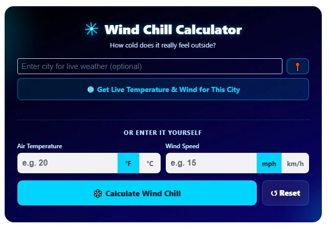
How to Use This Wind Chill Calculator
Using the calculator takes under a minute:
1. Enter your city or ZIP code (or tap the location button) to pull live temperature and wind speed automatically.
2. Or enter your own numbers air temperature and wind speed if you already know the current conditions. Use the sustained wind speed rather than gusts; a brief gust doesn’t reflect the steady cooling effect the formula is built around.
3. Hit Calculate. You’ll instantly see the feels-like temperature, a color-coded risk level, and an estimated frostbite time if conditions are severe enough.
4. Copy or share your result with one tap if you want to send it to family, a coworker, or a group chat.
Try it now — scroll up and run your own numbers through the wind chill calculator before reading further.
How Is Wind Chill Calculated?
The NWS Formula
The U.S. National Weather Service (NWS) uses this formula to calculate wind chill:
Wind Chill = 35.74 + 0.6215T − 35.75(V^0.16) + 0.4275T(V^0.16)
Here, T is the air temperature in °F, and V is the wind speed in mph. You don’t need to do this math by hand that’s exactly what this tool handles for you, instantly.
Why It Only Applies Below 50°F and Above 3 mph
The wind chill formula isn’t meant to apply to every day of the year. It’s only valid when:
- Air temperature is 50°F (10°C) or lower
- Wind speed is above 3 mph (4.8 km/h)
Outside that range, wind doesn’t meaningfully change how cold the air feels. If you plug in numbers outside this range, a good calculator will tell you the formula doesn’t apply not just spit out a misleading result.
Wind Chill Risk & Frostbite Time Chart
Once wind chill drops low enough, frostbite becomes a real clock you’re racing against. Here’s roughly how the risk breaks down:
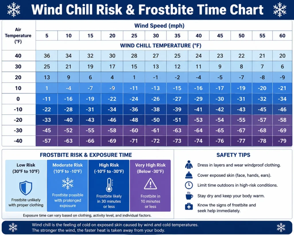
| Wind Chill | Risk Level | Frostbite Time |
|---|---|---|
| 32°F and above | Low Risk | Not a frostbite concern |
| 0°F to 32°F | Moderate Risk | Not typically a frostbite concern |
| -18°F to 0°F | High Risk | About 30 minutes |
| -35°F to -18°F | Very High Risk | About 10 minutes |
| Below -35°F | Extreme Risk | 5 minutes or less |
Frostbite happens when skin and the tissue beneath it start to freeze it usually hits fingers, toes, ears, noses, and cheeks first. Before that, you’ll often get frostnip the same numbness and tingling, but without any ice crystals forming in the skin yet. Frostnip is your body’s early warning sign; if you get inside and warm up at that stage, there’s usually no lasting damage. Left untreated, frostbite can lead to permanent damage or complications like compartment syndrome, so treat these frostbite time estimates as a real countdown, not a rough guess.
Why the Same Wind Chill Number Can Have Very Different Frostbite Times
Here’s something most wind chill charts don’t explain clearly: two very different weather setups can produce the exact same wind chill number but not the same frostbite risk.
NOAA gives a clear example of this:
- -40°F with a 5 mph wind → wind chill of -58°F → frostbite in about 10 minutes
- -20°F with a 45 mph wind → wind chill also -58°F → frostbite in about 5 minutes
Same wind chill number. Half the frostbite time. That’s because wind speed itself accelerates heat loss beyond what the wind chill number alone captures. The lesson: don’t just glance at the final feels-like number check the actual wind speed too, especially in genuinely windy conditions.
US vs. Canada: Is Wind Chill Calculated the Same Way?
Not exactly. The U.S. wind chill index and Canada’s wind chill index are both built to describe the same idea how cold the wind makes you feel but they use slightly different formulas and reference points. Environment Canada’s version is calibrated for how Canadians typically experience cold, which means the same raw temperature and wind speed can occasionally show a slightly different wind chill number depending on which country’s formula is used.
If you’re comparing wind chill readings across the border, small differences aren’t a bug they’re just two related but distinct systems.
Who’s Most at Risk in Cold, Windy Weather?
Wind chill isn’t equally dangerous for everyone. According to public health guidance from the CDC and Massachusetts Department of Public Health, certain groups face higher risk of hypothermia and frostbite:
- People with chronic conditions like diabetes, hypertension, or heart disease
- Older adults
- People with limited ability to sense cold or communicate discomfort
- People with inadequate clothing or heating
- People who smoke or drink alcohol in cold conditions
If you fall into any of these groups or you’re responsible for someone who does treat a feels-like temperature reading as a hard limit on outdoor time, not just a suggestion.
Wind Chill and School Closures
Wind chill is one of the most overlooked reasons schools cancel class even when there’s no snow falling at all. Many districts close or delay when wind chill drops below a certain threshold (often around -15°F to -25°F), specifically to protect kids waiting at bus stops. If you’re checking wind chill because you’re also wondering about tomorrow’s classes, our Snow Day Calculator covers that exact question using the same live weather data.
How to Stay Safe in Low Wind Chill
- Layer up. A wind-resistant outer layer matters more than one thick coat.
- Cover exposed skin. Ears, nose, and fingers are the first areas frostbite affects.
- Limit exposure time. Match your time outside to the frostbite estimate from the calculator, not just how cold it “feels” to you at first.
- Check wind speed, not just temperature. As shown above, wind speed changes your real exposure time even at the same wind chill number.
- Watch for hypothermia symptoms, uncontrollable shivering, confusion, and slurred speech mean it’s time to get inside immediately.
Run your numbers through the tool above before you decide how long to stay outside today.
Limitations of This Wind Chill Calculator
This tool gives a standardized estimate from the official NWS formula not a personalized reading. A few things to keep in mind:
- Not valid above 50°F or under 3 mph wind — outside that range, the formula doesn’t apply.
- Doesn’t account for clothing, body size, or cold tolerance — treat it as a baseline, not an exact reading for you personally.
- Not the same as an official advisory or warning — a wind chill advisory (dangerously cold) or warning (life-threatening) comes from real-time NWS monitoring, not a single calculation.
- Doesn’t adjust for microclimates — buildings, valleys, and windbreaks can make a specific spot feel warmer or colder than the number above.
Its summer counterpart, the heat index, does the same job in reverse telling you how hot it actually feels on humid days.
Ready to check your own conditions? Scroll back up to the calculator, enter your city, and see exactly how cold it feels where you are right now.