
Winter Storm Warning — What It Means, How Serious It Is, and What Happens to Schools
A Winter Storm Warning is issued by the US National Weather Service when hazardous winter weather is not just possible it is expected. Common NWS guidance includes 6 or more inches of snow within 12 hours, 8 or more inches within 24 hours, or significant ice accumulation, although exact thresholds vary by region. When a warning is active, conditions are expected to create hazardous travel conditions, and school closures may become more likely depending on your region, storm timing, and local district decisions.
What Is a Winter Storm Warning?
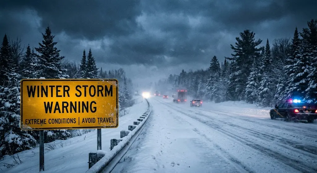
A Winter Storm Warning is the NWS’s formal declaration that dangerous winter weather will affect your area in the next 12 to 36 hours. It sits between a Winter Storm Watch which signals that conditions are possible and a Blizzard Warning, which indicates the most extreme winter conditions.
The National Weather Service issues warnings through its network of regional Weather Forecast Offices. When meteorologists reach approximately 80 percent confidence that warning-level conditions will occur, the warning goes out. A Watch, by comparison, is issued at around 50 percent confidence, typically 24 to 48 hours before the storm arrives.
On the Emergency Alert System, a Storm Warning carries the SAME broadcast code WSW. When you hear that code on television or weather radio, your area is under an active warning.
What Triggers a Winter Storm Warning? The Official NWS Criteria
A Winter Warning is issued when forecasters are confident that hazardous winter weather is expected to significantly impact an area. While the (NWS) provides national guidance, exact warning criteria can vary between local Weather Forecast Offices because winter conditions and community impacts differ by region.
In many parts of the United States, a Winter Storm Warning may be issued when one or more of the following conditions are expected:
- 6 inches (15 cm) or more of snow within 12 hours
- 8 inches (20 cm) or more of snow within 24 hours
- Significant freezing rain or ice accumulation that creates dangerous travel conditions
- A combination of snow, sleet, freezing rain, and strong winds that can seriously disrupt travel or daily activities
These snowfall amounts are common guidance, not fixed rules for every location. Local NWS offices adjust criteria based on regional climate, terrain, infrastructure, and how communities typically respond to winter weather.
For example, the same amount of snow can create very different impacts depending on location. A few inches may cause major disruptions in areas that rarely experience winter weather, while regions with regular snowfall may continue normal operations because of better preparation and snow removal resources.
Ice can sometimes create more disruption than heavy snowfall. Freezing rain coats roads, bridges, sidewalks, and power lines with a layer of ice that is difficult to remove, increasing risks of accidents, falling branches, and power outages.
The NWS does not consider snowfall totals alone. Forecasters also evaluate ice, wind, timing, infrastructure, and expected impacts on transportation and public safety before issuing a Winter Storm Warning.
Winter Storm Warning vs. Watch vs. Advisory vs. Blizzard Warning
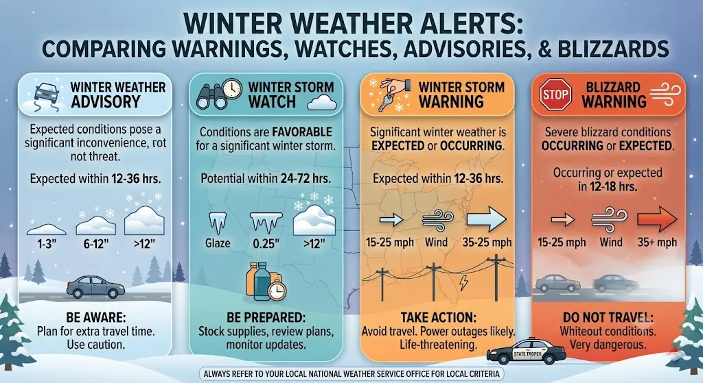
These four alerts are often confused, but each represents a different level of winter weather risk. Understanding the differences helps you know when to start preparing, when to change travel plans, and when school closures become more likely.
| Alert | Typical Timing | What It Means | Typical School Impact |
| Winter Weather Advisory | Usually within 24 hours | Winter weather will cause inconvenience and hazardous travel, but conditions are generally less severe than warning criteria. | Delays or localized closures may occur. |
| Winter Storm Watch | About 24–48 hours before the storm | Significant winter weather is possible. Forecast confidence is increasing, but the exact track or intensity may still change. | Schools begin monitoring conditions and preparing contingency plans. |
| Winter Storm Warning | About 12–36 hours before the storm | Hazardous winter weather is expected and confidence is high enough that people should take action. | School delays or closures become much more likely, depending on local conditions. |
| Blizzard Warning | Usually issued shortly before or during the event | Extremely dangerous conditions are expected, including sustained winds of at least 35 mph (56 km/h) and visibility below ¼ mile (400 m) for three hours or longer. | Widespread closures and major travel disruptions are common. |
A Winter Storm Watch gives you time to prepare because severe winter weather is possible but not yet certain. Once confidence increases and warning criteria are expected to be met, the Watch is typically upgraded to a WS Warning.
A Winter Weather Advisory is issued for lower-impact events that can still create hazardous travel conditions. Roads may become slippery, visibility may decrease, and daily routines can be disrupted, but conditions are generally less severe than those required for a Warning.
A Blizzard Warning represents one of the most serious winter weather alerts. Unlike a Winter Storm Warning, it is defined by dangerous wind and visibility, not snowfall totals alone. Heavy snow without strong winds may still qualify for a Winter Storm Warning rather than a Blizzard Warning.
How Serious Is a Winter Storm Warning?
Serious enough to take action but how disruptive it becomes depends on three key factors: the type of storm, when the snow or ice arrives, and your region’s ability to respond to winter weather.
When bomb cyclones are involved
Some of the most disruptive Winter Storm Warning events in recent years have been associated with bomb cyclones—storms that rapidly intensify when their central pressure drops by at least 24 millibars within 24 hours, a process known as bombogenesis. During Winter Storm Hernando in February 2026, a bomb cyclone and nor’easter affected the US East Coast, leading to emergency declarations across several states, thousands of flight cancellations, and widespread school closures. The event showed how quickly conditions can worsen once a rapidly intensifying winter storm develops.
These storms can strengthen much faster than typical winter systems and may cause conditions to deteriorate rapidly. In some cases, a Winter Storm Warning may remain in effect alongside a Blizzard Warning if blizzard criteria are also met.
Power outages as a closure trigger
Heavy snow is only one reason schools close during a Winter Storm Warning. Ice accumulation, strong winds, and falling trees can damage power lines, leaving schools without heat or electricity. During the January 2026 winter storm, more than 800,000 customers across 20+ states lost power, according to NOAA. Even after major roads were cleared, some schools remained closed because buildings could not operate safely or staff were unable to reach campus.
Polar vortex disruptions
Some of the most widespread Winter Storm Warnings occur when a polar vortex disruption allows Arctic air to move much farther south than usual. When this extremely cold air combines with moisture from the Gulf of Mexico or the Atlantic Ocean, it can produce heavy snow, freezing rain, and dangerous travel conditions across large areas.
What a Winter Storm Warning Actually Means for Schools
A Storm Warning does not automatically close schools, but it is one of the strongest indicators that a closure or delay is likely. The final decision is always made by local school districts after reviewing weather forecasts, road conditions, and transportation safety.
The decision timeline
In most US school districts, the decision process begins the evening before the storm. Superintendents monitor National Weather Service updates and local road reports, while transportation departments assess bus routes and weather forecasts overnight. Final decisions are typically made between 4:30 AM and 6:00 AM, with notifications sent to families through district websites, phone alerts, email, social media, and local news.
Bus routes matter more than snowfall
One of the biggest factors in a school closure decision is whether school buses can operate safely. Rural roads, bridges, steep hills, untreated streets, and overnight refreezing often create greater risks than snowfall totals alone.
Storm timing is equally important. Snow or freezing rain that arrives between 3 AM and 7 AM is far more disruptive because road crews have limited time to clear and treat roads before the morning commute.
Does a Winter Storm Warning mean schools will close?
Not necessarily. The impact depends largely on your location and how prepared your community is for winter weather.
- Deep South (Texas, Georgia, Alabama): Even modest snow or ice during a Winter Warning often leads to school closures because winter-weather infrastructure is limited.
- Mid-Atlantic and Southeast: Closures are common, but the storm’s timing often determines whether schools close, delay opening, or remain open.
- Midwest and Northeast: Schools may close, delay, or remain open depending on snowfall, ice accumulation, road conditions, and local experience with winter weather.
- Northern states (Minnesota, Wisconsin, Michigan, Upstate New York): Districts generally have a higher tolerance for snowfall, although dangerous wind chills or ice can still lead to closures.
Virtual snow days
Many school districts now use eLearning or virtual learning days instead of traditional snow days. During an active Winter Storm Warning, students may attend classes remotely rather than receiving a full day off, so it’s important to check your district’s inclement weather policy.
If a Winter Storm Warning has been issued for your area, check our Live Snow Update page for current alerts and use the Snow Day Calculator to estimate the likelihood of a school closure tomorrow.
Why the Same Warning Closes Schools in One City But Not Another
A few inches of snow in Atlanta can close schools across the city, while communities in Buffalo, New York or Minneapolis may continue operating through much heavier snowfall.
The difference is not the weather itself it is how each region is prepared to manage it. Infrastructure plays a major role, including the availability of snowplows, road salt, experienced road crews, and established winter transportation plans. Areas that deal with snow every winter can often keep roads and school bus routes operational more efficiently than places where winter storms are uncommon.
General school responses also vary by region:
- Upper Midwest & Great Lakes: Schools are generally more accustomed to heavy snowfall, so closure decisions often depend on overall impacts, road conditions, and wind chill rather than snowfall totals alone.
- Northeast: Many districts can remain open during moderate snow events, but heavy snow, ice accumulation, or blizzard conditions frequently lead to delays or closures.
- Mid-Atlantic: Snowfall, freezing rain, and overnight storm timing often have a significant impact on school decisions because road conditions can deteriorate quickly.
- Southern States: Even relatively light snow or ice can cause widespread disruptions due to limited winter-weather infrastructure and treatment equipment.
- Canada & the UK: School responses vary by province or local authority, depending on regional winter preparedness and transportation conditions.
The National Weather Service considers these regional differences when issuing winter storm alert. A warning represents expected local impacts, not just snowfall totals. That is why the same Winter Warning alert may keep schools open in one region while prompting delays or closures in another.
What to Do When a Winter Storm Warning Is Issued
Before the Storm
- Check NWS alerts for your exact location rather than relying on regional headlines.
- Fill your vehicle’s fuel tank and check tire pressure.
- Keep enough food, water, and essential medications for at least two to three days.
- Charge mobile devices and portable power banks.
- Prepare for possible power outages by checking your backup heating or emergency supplies.
- Make sure you’re enrolled in your school district’s notification system.
- If school closures are possible, monitor official district updates throughout the evening.
During the Warning
- Avoid unnecessary travel unless it is essential.
- If you must drive, carry an emergency kit and let someone know your planned route.
- Watch for changing conditions, especially freezing rain, blowing snow, and reduced visibility.
- If temperatures continue to fall, use our Wind Chill Calculator to assess outdoor safety.
- Check school announcements between 5:30 AM and 6:00 AM, when most districts publish closure or delay decisions.
After the Warning Expires
A winter weather emergency alert ending does not always mean conditions are safe. As skies clear, temperatures often drop below freezing again, causing melted snow and slush to refreeze into black ice.
Because of this, roads can be more hazardous the morning after the storm than during the heaviest snowfall. Some schools that remained open during the storm may delay or cancel classes the following day due to icy roads, unsafe bus routes, or lingering power outages.
Continue checking NWS updates, local road conditions, and school announcements until travel conditions have clearly improved.
The Timeline From Warning to School Announcement
- 48 hours before: A Winter Storm Watch may be issued when forecasters believe hazardous winter weather is becoming increasingly likely. This is the time to begin monitoring forecasts and preparing for possible disruptions.
- 24 to 36 hours before: If confidence increases, the Watch is upgraded to a Storm Warning. Review your travel plans, prepare emergency supplies, and check your school district’s notification system.
- 7 to 10 PM the evening before: Check the latest NWS forecast and warning updates. School districts closely monitor overnight forecast changes before making early-morning decisions.
- 3 to 7 AM on storm day: This is the most critical period for school transportation. Snow or ice during these hours leaves road crews with less time to treat roads before buses begin their routes.
- 4:30 to 6:00 AM: Superintendents review road conditions, transportation reports, weather updates, and other local factors before making the final decision.
- 5:30 to 6:00 AM: Most districts publish closure or delay announcements through automated calls, text messages, websites, and social media.
After the warning expires: Continue monitoring road conditions and official weather updates. Melting snow can refreeze overnight, creating black ice that may affect travel and even school operations the following day.
Winter Storm Warnings in Canada and the UK
Canada
Environment and Climate Change Canada (ECCC) issues winter weather warnings using terminology that differs from the US National Weather Service. Depending on the expected conditions, alerts may include Winter Warnings, Snowfall Warnings, Freezing Rain Warnings, or Blizzard Warnings. Snowfall Warning criteria vary by region, reflecting Canada’s diverse climate and geography.
School closure decisions are made by individual school boards or provincial authorities rather than ECCC. Provinces such as Alberta and Saskatchewan are generally more accustomed to heavy snowfall, while responses in Ontario and British Columbia can vary depending on local weather conditions, transportation, and infrastructure.
United Kingdom
The UK Met Office uses a colour-coded warning system Yellow, Amber, and Red instead of the NWS alert hierarchy. A Red Weather Warning is the highest alert level and indicates a significant risk to life, travel, and essential services, making it broadly comparable to the impacts of a US Winter Storm or Blizzard Warning.
School closure decisions are made individually by schools or local authorities based on local conditions. Because there is no nationwide closure policy, neighbouring schools can make different decisions during the same winter weather event.
Conclusion
When a Winter Storm alert appears for your area, you now know exactly what triggered it, what the NWS expects, and how it will move through the decision process that ultimately determines whether your school opens in the morning.